What do we do?

Our Services

Geotechnical Services

Our activity in the geoengineering field is mainly focused on the following services:

  • Geotechnical site recognition and characterization.
  • Ground modelling, identifying characteristics related to geology, morphology, seismicity, hydrology, and their historical changes.
  • Geotechnical site exploration.
  • Geoengineering field and laboratory tests.
  • Collection, recording and interpretation of data for assessing the performance of geotechnical structures.

Geotechnical Engineering

The permanent update of knowledge and the experience accumulated over more than four decades have allowed us to be pioneers in the fields of Environmental Geotechnics, Pipeline Geotechnics and Road Geotechnics.

Our Consulting activity covers the studies, consultancies and audits of Civil Engineering Projects and Geotechnical Engineering Problems mainly in the following areas:

  • Slope stability.
  • Oil and gas pipelines.
  • Oil and gas facilities, drilling rigs, pumping and storage stations, flow lines and access roads.
  • Hydroelectric projects.
  • Bridges and tunnels.
  • Roads and transportation in general.
  • Excavations in difficult subsoil conditions.
  • Foundations (for houses, buildings, bridges, industrial plants, and other structures.)
  • Industrial facilities.
  • Construction materials.
  • Mining.
  • Maritime and river projects.

Environmental Geotechnics

In this activity, we seek to harmoniously integrate engineering projects into the environment, employing geotechnical tools for the control of erosion, slope stability and excavations, and for the use and disposal of earth and rock materials.

Advice and technical supervision of projects

We provide geotechnical advice in all design and construction stages of civil engineering projects, providing constant support through meetings and by workshops as required.

Numerical Modelling

Our geo-designs are developed and assisted by the following numerical modelling programs in two and three dimensions:

  • OPTUM G2 and OPTUMG3: State-of-the-art computational tools for finite element analysis in 2D and 3D, to facilitate and streamline geotechnical analysis and design.
  • SLIDE: For analysis of slope stability in soils applying 2D limit equilibrium methods.
  • ROCKFALL: For assessing slopes at risk for rock falls.
  • WEDGE: For evaluating the stability of 3D surficial rock wedges.

Teaching, training and research activity

Our relationship with teaching started before the formation of our company and remains in force today. The hiring of Civil Engineering and Geology students allows us to provide training for our future professionals.

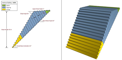
We provide training and training-related services on various topics such as Pipeline Geotechnics, Slope Stability and Environmental Geotechnics.

The teaching activity keeps us updated. An active participation of our professionals in congresses and seminars is part of our sponsorship policy.